Europe vs Africa: drawing the edge of a continent
Africa is roughly three times Europe's area here. Before reading the ratio, it helps to know where this map puts Europe's eastern edge and why adding up whole countries gives a different result.
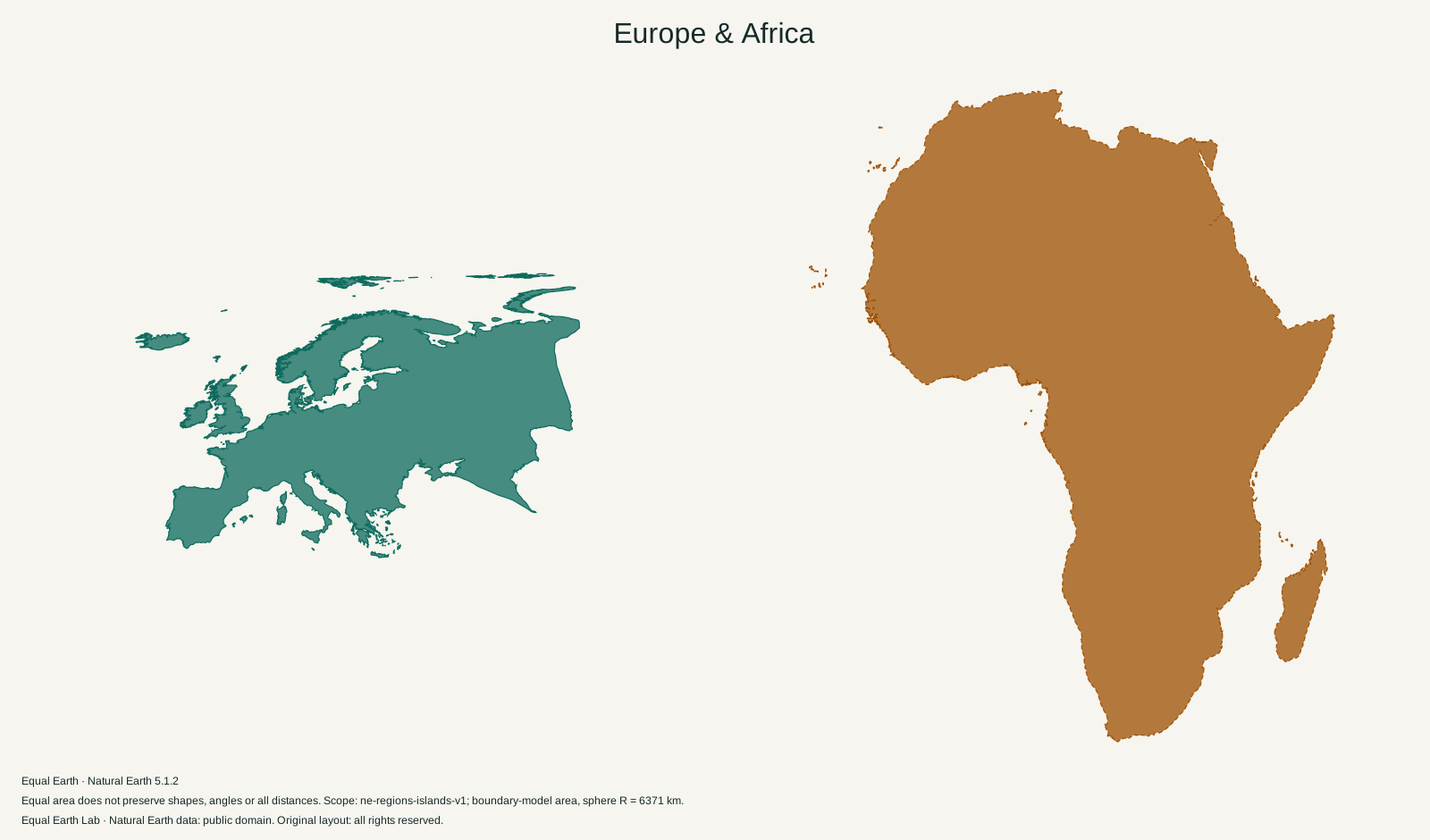
Europe is 0.33 times the boundary-model area of Africa.
| Place | Boundary-model area estimate |
|---|---|
| A · Europe | 9,920,831 km² |
| B · Africa | 29,948,465 km² |
Both silhouettes use one shared Equal Earth scale. Moving a silhouette here is a flat cutout comparison; it does not relocate the place on the globe. Shapes still reflect projection distortion. Try spherical relocation
Europe and Africa face each other across the Mediterranean. On a conventional world map, the eye can travel from Scandinavia down to the Mediterranean shore and then compare that long span with Africa. A continent’s height, however, does not reveal how much ground its outline contains.
The Africa silhouette above has 3.02 times the area of Europe. The underlying figures are 29,948,465 km² and 9,920,831 km², respectively. Europe is about one third as large under the physical-continent definitions used on this site.
There is no ocean along Europe’s eastern edge
Europe and Asia belong to a continuous landmass, so their division needs a convention. The Ural Mountains form part of the familiar boundary through western Russia. Farther south, the Ural River runs toward the Caspian Sea. NASA’s views of the Ural Mountains and Uralsk describe these geographic reference points.
A political country layer alone cannot make this division. Russia crosses it. So does Kazakhstan in the physical partition used for this comparison. Türkiye also has territory on both sides of the continent boundary. Counting each of those countries in full would bring Asian land into a number labelled “Europe.”
The site therefore clips its land data with a fixed physical-continent partition. The resulting Europe outline contains the portions inside that partition, plus the mapped islands assigned to Europe. It does not depend on which continent a country happens to be filed under in a dropdown menu.
Four labels that lead to four different questions
| Label | What a comparison using it needs to measure |
|---|---|
| Europe | A stated physical or regional definition of the continent |
| European Union | The territory included in a specified EU statistical scope |
| Russia | The complete country outline, including Asian territory |
| Africa | A stated continent definition and island coverage |
This page answers the first and last questions. The European Union is a political grouping, so an EU figure cannot simply replace the Europe figure. Similarly, the Russia and Africa comparison includes all the mapped Russian territory and therefore gives a much smaller gap than the one shown here.
Our continent masks come from Natural Earth’s physical geography layer. The scope record documents how those masks meet the land polygons. This is a reproducible cartographic choice; it should not be presented as the only possible definition of a continent.
Peninsulas draw the eye farther than their area suggests
Europe’s outline reaches into Scandinavia and around the Iberian, Italian and Balkan peninsulas. Much of the space between those extensions is water. Africa’s broad northern mainland fills a larger share of its surrounding rectangle, then narrows toward the south. Two thumbnails fitted to matching boxes can hide that difference.
The silhouettes use one scale, so the empty spaces remain empty and the filled areas retain their proper relationship. Europe’s long coast can still make it seem visually complicated or extensive. Neither coastline length nor the number of peninsulas is a substitute for area.
Latitude adds another bias on Mercator. Northern Europe receives more enlargement than land close to the equator. Select Europe on the world map, switch between Equal Earth and Mercator, and pay attention to Scandinavia. Then follow Africa across the equator. The projection changes the impression without changing the continent definitions.
Islands do not follow a simple country list
Iceland belongs to this Europe scope; Greenland and Cyprus do not. Africa includes Madagascar and its assigned island groups. The African mainland mask also places Sinai outside Africa, even though it is part of Egypt. That is a useful example of why a physical-continent area differs from the sum of countries commonly grouped into a region.
Keep “physical continents, including the mapped islands” with this comparison if you reuse it. The ratio answers a geographic question more precisely when the caption makes its boundaries visible.
Sources & further reading
Map calculations use the fixed dataset described in our methodology.