Metropolitan France vs Spain: a small gap with a precise label
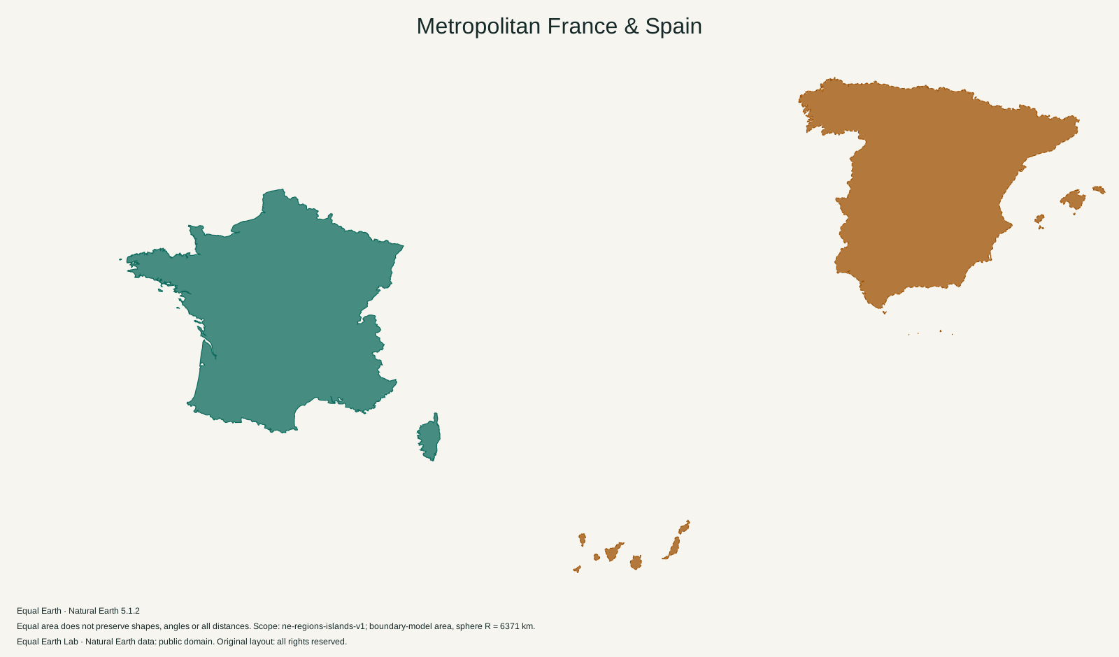
Metropolitan France is about eight percent larger than Spain in this boundary model. That includes Corsica for France and the Balearic and Canary Islands for Spain, so neither outline is limited to the mainland.
Metropolitan France is 1.08 times the boundary-model area of Spain.
| Place | Boundary-model area estimate |
|---|---|
| A · Metropolitan France | 546,435 km² |
| B · Spain | 506,326 km² |
Both silhouettes use one shared Equal Earth scale. Moving a silhouette here is a flat cutout comparison; it does not relocate the place on the globe. Shapes still reflect projection distortion. Try spherical relocation
Metropolitan France covers 546,435 km² in the silhouettes above. Spain covers 506,326 km². The ratio is 1.08, leaving a difference of about 40,000 square kilometres in this model.
These neighbours make a useful comparison because the gap is modest and their mainland outlines are familiar. They also expose a problem hidden in many country-size tables: a short country name does not always tell you which territory has been measured.
The word “metropolitan” carries part of the answer
In French statistics, metropolitan France refers to the European part of France. INSEE’s definition uses the 96-department geographic scope. Corsica belongs in it; INSEE lists Corse as a French region.
The outline on this page therefore includes Corsica and the mapped coastal islands as well as the main European landmass. It excludes French Guiana, Guadeloupe, Martinique, Réunion, Mayotte and the other overseas territories. A figure for a broader French national scope would answer a different question.
This also means that “metropolitan” and “mainland” are not interchangeable labels. Corsica is an island in the Mediterranean, but it still belongs to metropolitan France. Dropping it because it is detached from the mainland would change the intended comparison.
Spain extends beyond the Iberian Peninsula
Spain’s mainland occupies most of the Iberian Peninsula, beside Portugal. Its geography also includes the Balearic Islands in the Mediterranean, the Canary Islands in the Atlantic, and Ceuta and Melilla on the North African coast. Spain’s National Geographic Institute describes that arrangement in its geographic overview.
Those detached pieces belong to the Spain scope here where the boundary dataset represents them. The Canary Islands sit far from the peninsula, so keeping their location and scale can create a broad frame around an otherwise compact mainland shape. Empty Atlantic space inside that frame does not add to Spain’s area.
A mainland-only map would omit these pieces. It would be suitable for some regional questions about the Pyrenees or the Iberian Peninsula, but it should be labelled accordingly before being compared with a complete country outline.
Do the islands account for the whole difference?
No. The gap in this model is about 40,000 km², while the Corsica polygon contributes about 8,650 km². Removing Corsica alone would still leave the remaining metropolitan French geometry larger than the complete Spain geometry used here.
Those figures come from the same source polygons as the map. They are useful for checking the direction and scale of the comparison, rather than attributing the entire result to a detached island. Spain’s own islands contribute area on the other side of the calculation.
The mainland shapes carry most of both totals. France’s familiar near-hexagonal outline and Spain’s broad peninsular outline occupy similar amounts of room, which is why this pair feels closer than comparisons such as Africa and Greenland. The numerical difference is easier to judge from the common-scale fills than from the countries’ widths.
A relief map answers another question about these neighbours
The Pyrenees are an obvious feature near their shared border. Farther into Spain, the elevated interior occupies much of the peninsula. The National Geographic Institute’s geological account describes the Meseta and the peninsula’s development.
View Spain with physical relief to see that interior, then select metropolitan France. The colour and shading reveal differences within outlines that otherwise look like two fairly similar blocks of land. They do not alter the area calculation.
If this comparison is used in a presentation, keep the full name “metropolitan France” in the caption. “Metropolitan France and Spain, including the mapped islands” tells the reader far more than another decimal place in the ratio.
Sources & further reading
Map calculations use the fixed dataset described in our methodology.