Russia vs Africa: width is only half the picture
Russia stretches across the north of a world map, yet Africa has about 1.78 times its area in this boundary model. Russia's width and northern latitude both make the gap harder to judge by eye.
Russia is 0.56 times the boundary-model area of Africa.
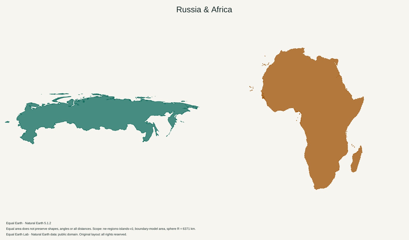
| Place | Boundary-model area estimate |
|---|---|
| A · Russia | 16,854,313 km² |
| B · Africa | 29,948,465 km² |
Both silhouettes use one shared Equal Earth scale. Moving a silhouette here is a flat cutout comparison; it does not relocate the place on the globe. Shapes still reflect projection distortion. Try spherical relocation
The Russian silhouette above covers 16,854,313 km², while Africa covers 29,948,465 km². Russia is about 56 percent of Africa’s area. Put the comparison the other way around and Africa is 1.78 times as large.
That result includes the whole mapped country. It is not a comparison with European Russia alone. Nor does it leave out the islands or the pieces that sometimes appear at the opposite edge of a world map.
A country that extends through two continents
Russia’s long outline crosses the Europe-Asia divide and continues through northern Asia toward the Pacific. The Ural Mountains provide one of the familiar geographic markers of that continental division. They do not mark the eastern end of the country.
Beyond the Urals lies a vast part of Russia that is easy to compress into the single word “Siberia.” A NASA Earth Observer report on Siberian and Far Eastern forests describes the boreal forest region extending from the Urals toward the Pacific, with tundra to its north. The long band of colour on a physical map therefore covers different environments as well as a large east-west extent.
Africa has a different arrangement. Its mainland spreads broadly across the north and reaches into both hemispheres, with the equator crossing its interior. The filled silhouette extends substantially in both width and height. Comparing Russia’s longest dimension with Africa’s longest dimension ignores the land on either side of those lines.
This is also why “largest country” and “larger than a continent” are separate claims. Country boundaries and continent boundaries divide the Earth’s surface in different ways. This page measures one complete country against one physical continent.
The small piece at the other edge still belongs to the total
A flat world map needs a seam. With a central meridian at 0°, that seam is commonly placed along the antimeridian, at 180° longitude. Russia’s far eastern geometry reaches across it. A piece of the same country can therefore appear at the left edge while most of Russia appears on the right.
The split is a property of the display. The underlying area calculation includes both pieces. Moving the seam can bring them back into a more continuous view; it does not add land to the country. D3’s projection documentation describes the rotation and antimeridian clipping used in this kind of map rendering.
Open a world map centred at 150° east. Compare it with a view centred at 0°. Follow the far eastern outline as it moves away from the seam. The selected area value stays fixed, even though the arrangement on the page changes substantially.
Moving south changes the drawing more than moving the seam
Changing the central meridian changes where the map is cut. Moving a country copy toward the equator is a different experiment: it places the same spherical shape at new latitudes.
Select Russia on Mercator, choose Compare with this country, and drag the copy south. Its apparent area contracts as it leaves the high northern latitudes. The northern and southern parts of the country do not receive identical enlargement, so the outline changes unevenly. Trying to correct a Mercator screenshot by applying one scale factor to the whole country will miss that detail.
Use the common-scale silhouettes on this page for the area answer. Use the moving copy to understand why the original world map gave a different impression. A country can look wider, narrower, split or continuous while its calculated area remains unchanged.
Africa here includes Madagascar and the other mapped islands in the site’s continent scope. Russia uses all of its polygons in the same boundary version. For the comparison that deliberately cuts Russia at the continent division, continue to Europe versus Africa.
Sources & further reading
Map calculations use the fixed dataset described in our methodology.