Why world maps distort country sizes
A flat world map has to change the geometry of a curved surface. The useful question is which property it preserves, and what that choice does to the rest.
What changes when a globe becomes a map?
On a globe, lines of longitude converge toward the poles. On a rectangular Mercator map, those same lines stay parallel. The map must stretch the space between them as latitude increases. Mercator also increases the north–south scale by the same local factor, preserving angles while enlarging area. Equal Earth uses a different rule: it balances stretching in one direction with compression in another to preserve area.
That is why a familiar coastline can look wider or narrower when you switch projections. The coastline data can be identical. A projection is the mathematical rule that puts those geographic coordinates onto the page; changing that rule changes the picture.
Three properties are especially easy to confuse:
| Property | A question it answers | A common mistake |
|---|---|---|
| Area | How much surface does this region cover? | Treating the width of a country as its area. |
| Local angle | Do two nearby directions meet at the right angle? | Assuming this preserves the shape of a whole continent. |
| Distance | How far apart are two places? | Applying one ruler scale everywhere on a world map. |
Keeping one property does not imply keeping the other two. An equal-area map can make a region look elongated. A map that preserves local angles can make that same region far too large relative to another. This is a choice about what readers should be able to compare, rather than an error that disappears with a sharper image.
See the trade-off with identical circles
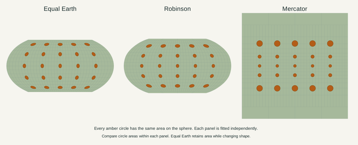
Every amber circle above has a five-degree angular radius on the sphere. The figures use the same generated boundary dataset. Each panel fits its world independently, so compare circles within a panel before comparing the panels themselves.
Equal Earth keeps the circles’ areas equal while changing their shapes. Mercator’s high-latitude circles grow; locally, the stretching is equal in all directions. Robinson changes both area and shape to make a broad, rounded world map. The documented properties are equal area for Equal Earth, local angle preservation for Mercator, and a compromise for Robinson.
How much larger does Mercator make a place?
In this site’s spherical Mercator model, local area scale relative to the equator is 1 / cos²(latitude). Evaluating that expression gives the following values:
| Latitude north or south | Local length scale | Local area scale |
|---|---|---|
| 0° | 1.00× | 1.00× |
| 30° | 1.15× | 1.33× |
| 60° | 2.00× | 4.00× |
| 80° | 5.76× | 33.16× |
The area factor is the square of the length factor because a small patch stretches in two dimensions. At 60°, twice the width and twice the height produce four times the area. These are local factors, calculated from the spherical Mercator equations. They are not a whole-country multiplier: Canada, for example, spans many latitudes.
What does “true size” mean on a map?
For Equal Earth, it means that two regions’ map areas have the same ratio as their areas on the chosen Earth model. It does not mean that one square centimetre always represents the same distance, or that an outline has the shape it would have on a globe.
The input boundaries matter too. Omitting an island changes the region being measured. Measuring land alone gives a different definition from measuring an outline that includes inland water. The projection preserves the area you supplied; it cannot repair an inconsistent definition. See how country areas are measured before comparing numbers from different sources.
Choose the property your reader needs
Use Equal Earth when relative geographic extent carries the message. Use the Equal Earth–Mercator comparison to show how a different priority changes that message. Robinson is useful for a general world overview when no exact area or angle guarantee is needed.
On the interactive map, select one country and switch projections. Its reported boundary-model area stays fixed while its outline changes. You can also create a comparison copy and move it across latitudes. The copy rotates on the sphere before it is projected, so its geographic area stays constant even when its map area does not.
For precise routes, surveying or local distance measurement, use an appropriate specialist map. A world projection makes a specific promise; reading the map well starts by identifying that promise.
Sources & further reading
Map calculations use the fixed dataset described in our methodology.