Equal Earth and the September 2026 UN map vote
The African Union reported that the UN General Assembly adopted a map-related resolution on 4 September 2026. The initiative promotes more faithful representation of geographic area.
What is confirmed?
In its 4 September 2026 communiqué, the African Union Commission welcomed the UN General Assembly’s adoption that day of a resolution championed by Togo on behalf of the African Group. The statement describes a call for more accurate representation of Africa and other world regions.
The Commission encouraged educational systems, publishers, international institutions and digital platforms to progressively promote maps that better reflect actual land areas. This is the substance of the AU statement, which is a public response to the action rather than the complete resolution text.
Last checked: 6 September 2026. The account above is attributed to the primary statement that we could inspect. We have not independently verified the complete adopted resolution text, final resolution number or recorded voting table for this page. Those details are therefore not presented here as established findings.
Which documents support this account?
| Source | What it establishes | Its limit |
|---|---|---|
| African Union communiqué, 4 September | The AU’s confirmation of adoption, Togo’s role and the Commission’s response. | A communiqué is not the full adopted resolution. |
| UN public summary | The UN’s indexed announcement describes encouragement to change misleading world maps. | The complete linked news report was not available for this review. |
| General Assembly meeting schedule | The indexed schedule lists action on the map-related draft at the 4 September meeting. | An agenda establishes scheduled business, not the final wording or voting outcome. |
When reading another report, check whether it cites the adopted text, a draft, an institutional statement or a news article. These can all be useful sources, but they answer different questions. A draft document identifier should not be mistaken for the final resolution number.
Why does Equal Earth enter the discussion?
The cartographic issue is relative area. Mercator greatly enlarges high latitudes compared with the equator. Equal Earth preserves the relative area of regions, as described in the PROJ projection reference. That makes it relevant when a world map’s colored footprint is meant to convey the amount of land in different places.
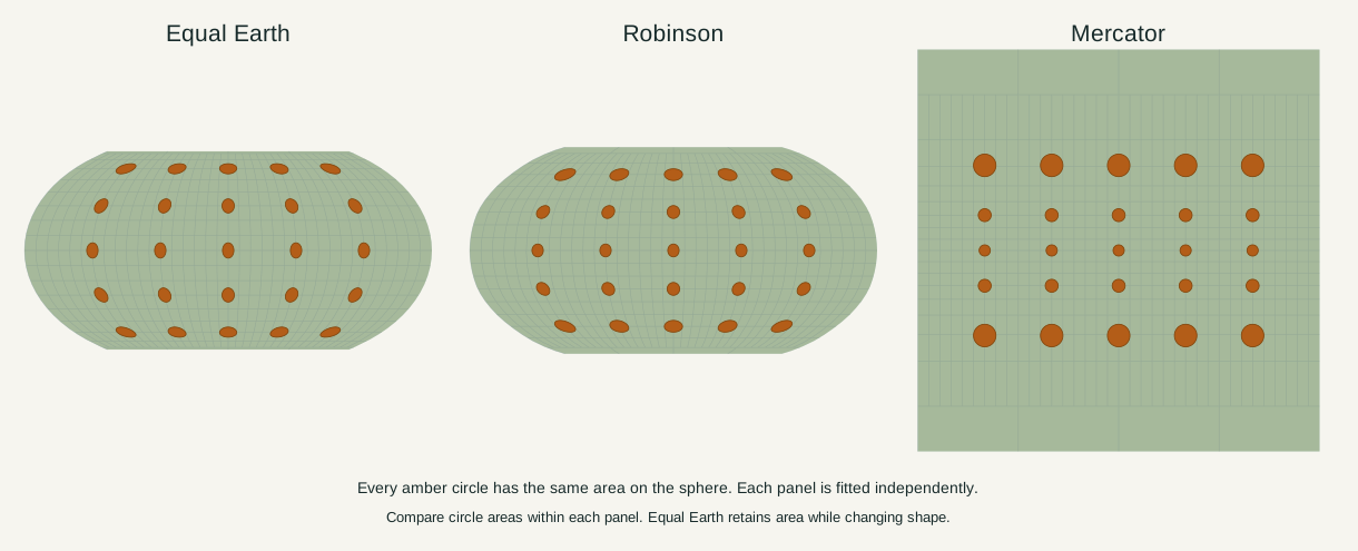
The circles in our figure were generated with identical spherical areas. Equal Earth preserves that relationship while changing their shapes. Mercator enlarges the circles toward the poles. The frames fit independently, so the meaningful comparison is among circles within each panel.
For a concrete geographic example, the site’s fixed boundary model gives Africa about fourteen times Greenland’s area. The Africa–Greenland comparison shows the underlying figures and geographic scopes. A changed map projection changes their relative footprint on the page; it does not add land to either place.
What should not be inferred from this event?
The sources reviewed here do not establish that every navigation service has changed its projection, that all existing Mercator maps must disappear, or that a particular platform has completed a migration. We do not infer a worldwide ban or a product rollout from an institutional call to improve representation.
Projection and boundaries are also separate matters. A projection transforms coordinates; the chosen geographic dataset supplies coastlines and boundaries. Using Equal Earth alone does not determine which boundary dataset a mapmaker uses.
Finally, the 2026 event is not the invention of Equal Earth. Its authors introduced the projection in 2018. The history guide explains that earlier work and links to the original paper.
Revision record
- 6 September 2026: Initial account based on the AU communiqué, with the limits of the accessible UN material stated explicitly. No unverified vote total or final resolution identifier has been added.
The full projection comparison explains the mathematical question independently of the news cycle. If you have the adopted primary document or evidence of an error in this account, use the corrections page to identify the specific claim and source.
Sources & further reading
- Communiqué of the Chairperson of the African Union Commission on the Adoption of the Correct The Map Resolution
- www.un.org
- public.e-delegate.un.org
- Equal Earth — PROJ documentation
Map calculations use the fixed dataset described in our methodology.